


- Posts: 4
TMY latitude/longitude discrepency
- Sirena DePue
- Topic Author
Less
More
25 Apr 2025 07:39 #14004
by Sirena DePue
TMY latitude/longitude discrepency was created by Sirena DePue
Hi,
I am trying to download TMYs, providing specific latitude/longitude locations.
Following the API directions here , when I use the example given "wkt": "POINT(-99.49218 43.83452)", I am able to download the data. When I put a different lat/long (specifically 41.6708, -70.91364), I receive a “No data available at the provided location” error. However, plugging this same lat/long into the NSRDB Viewer, I am able to pull the data. What can be done to fix this?
Thank you!
Please Log in or Create an account to join the conversation.
- Paul Gilman
Less
More
- Posts: 5706
25 Apr 2025 09:26 #14005
by Paul Gilman
Replied by Paul Gilman on topic TMY latitude/longitude discrepency
Hi Sirena,
The NSRDB PSM V3.2.2 dataset is deprecated and has been replaced by NSRDB GOES V4.0.0, so you should use GOES V4 to get the most up-to-date data.
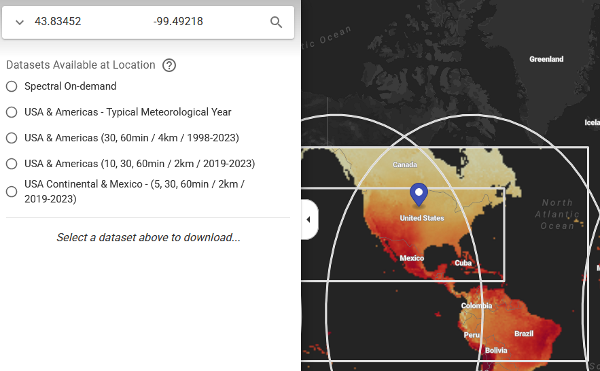
The different datasets cover different parts of the world. You can use the NSRDB Data Viewer to see what datasets are available in different parts of the world. However the NSRDB Viewer uses different names than the API documentation on the NREL Developer Network at developer.nrel.gov/docs/solar/nsrdb/ , so it can be tricky to identify the datasets on the map.
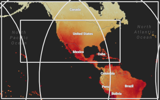
Both the PSM V3.2.2 and GOES V4.0.0 datasets cover the rectangle that includes much of North America, Central America, and part of South America:
The location 43.83452,-99.49218 is in the U.S., so is covered by GOES V4.0.0, which is labelled on the map as "USA & Americas (30, 60min / 4 km / 1998-2023)":
The location 41.6708, -70.91364 is also in the U.S., so you should be able to access data from either the GOES V4 or PSM V3 API endpoints.
For the wkt (well known text representation) parameter, be sure to put the longitude first followed by the latitude: "-70.91364+41.6708".
If you continue to have trouble, please share the URL you are using to make the request. (Remove your API key from the URL before posting it.)
Best regards,
Paul.
The NSRDB PSM V3.2.2 dataset is deprecated and has been replaced by NSRDB GOES V4.0.0, so you should use GOES V4 to get the most up-to-date data.
The different datasets cover different parts of the world. You can use the NSRDB Data Viewer to see what datasets are available in different parts of the world. However the NSRDB Viewer uses different names than the API documentation on the NREL Developer Network at developer.nrel.gov/docs/solar/nsrdb/ , so it can be tricky to identify the datasets on the map.
Both the PSM V3.2.2 and GOES V4.0.0 datasets cover the rectangle that includes much of North America, Central America, and part of South America:
The location 43.83452,-99.49218 is in the U.S., so is covered by GOES V4.0.0, which is labelled on the map as "USA & Americas (30, 60min / 4 km / 1998-2023)":
The location 41.6708, -70.91364 is also in the U.S., so you should be able to access data from either the GOES V4 or PSM V3 API endpoints.
For the wkt (well known text representation) parameter, be sure to put the longitude first followed by the latitude: "-70.91364+41.6708".
If you continue to have trouble, please share the URL you are using to make the request. (Remove your API key from the URL before posting it.)
Best regards,
Paul.
Attachments:
Please Log in or Create an account to join the conversation.
- Sirena DePue
- Topic Author
Less
More
- Posts: 4
28 Apr 2025 07:02 #14008
by Sirena DePue
Replied by Sirena DePue on topic TMY latitude/longitude discrepency
Hi Paul,
Thank you, I was able to get it working after switching the latitude and longitude. I had two follow-up questions:
1) Is there an easy way to just get the data in a dataframe within my code, instead of manually downloading from my email? This is what I have set up:
BASE_URL = " developer.nrel.gov/api/nsrdb/v2/solar/nsrdb-GOES-tmy-v4-0-0-download.json ?"
input_data = {
'attributes': 'ghi,dni,dhi,air_temperature,wind_speed,clearsky_dni,clearsky_ghi,relative_humidity',
'interval': '60',
'wkt': wkt,
'names': 'tmy-2022',
'api_key': API_KEY,
'email': EMAIL}
2) I see from the documentation that the irradiance data is based on geostationary satellites at a granularity level of 4km x 4km. Do the weather variables (temperature, wind speed, relative humidity) have the same level of granularity?
Thanks again!
Please Log in or Create an account to join the conversation.
- Paul Gilman
Less
More
- Posts: 5706
28 Apr 2025 10:01 #14009
by Paul Gilman
Replied by Paul Gilman on topic TMY latitude/longitude discrepency
Hi Sirena,
To download the file instead of receiving it by email, use ".csv" for the format in the base URL instead of ".json". See the GOES V4 endpoint description for more details: developer.nrel.gov/docs/solar/nsrdb/nsrdb-GOES-tmy-v4-0-0-download/ .
Yes, the meteorological data and solar resource data use the same grid cell size. See the Weather Data Publications page for links to publications about the NSRDB: sam.nrel.gov/weather-data/weather-data-publications.html . You might also consider contacting the NSRDB team for more detailed questions about the data: nsrdb.nrel.gov/contact-us .
Thanks,
Paul.
Please Log in or Create an account to join the conversation.
Moderators: Paul Gilman