


- Posts: 6
Spatial output
- Claud Balgobin
- Topic Author
Less
More
11 Apr 2025 09:18 #13987
by Claud Balgobin
Spatial output was created by Claud Balgobin
Really appreciate the Spatial displays.
Can you help me understand why the output spatial displays end before the row spacing estimated distance?
In this case, it was 11.473m; however, the plot ends at approximately 10.8 m.
Just for clarification:
The first display describes the ground irradiance between the rows - Does it start from the lower end of the front panel to the lower end of the adjacent row of panels which is 11.473m?
The second display describes the module rear irradiance under the panel - In this case it was calculated to be approximately 4.5m however the display stops at 4.2m.
Thanks
Claud
Attachments:
Please Log in or Create an account to join the conversation.
- Paul Gilman
Less
More
- Posts: 5706
14 Apr 2025 18:00 #13991
by Paul Gilman
Replied by Paul Gilman on topic Spatial output
Hi Claud,
The diagram on the Location and Resource page under "Albedo - Sky Diffuse Model - Irradiance Data (Advanced)" indicates how the ground under the array is defined for the monthly spacial albedo data. The diagram changes automatically based on the tracking option on the System Design page.
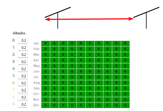
For 1-axis tracking, the ground area is defined by the tracking axis: The distance between the tracking axis of neighboring rows defines one side of the rectangle between rows:
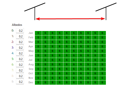
For a fixed array, the ground area is defined by the bottom of the row: The distance between neighboring row bottoms defines one side of the rectangle between rows:
Best regards,
Paul.
The diagram on the Location and Resource page under "Albedo - Sky Diffuse Model - Irradiance Data (Advanced)" indicates how the ground under the array is defined for the monthly spacial albedo data. The diagram changes automatically based on the tracking option on the System Design page.
For 1-axis tracking, the ground area is defined by the tracking axis: The distance between the tracking axis of neighboring rows defines one side of the rectangle between rows:
For a fixed array, the ground area is defined by the bottom of the row: The distance between neighboring row bottoms defines one side of the rectangle between rows:
Best regards,
Paul.
Please Log in or Create an account to join the conversation.
Moderators: Paul Gilman