


- Posts: 3
Land Area, Tilt and Ground Coverage Ratio
- Demba
- Topic Author
Less
More
12 Jan 2024 08:59 #12817
by Demba
Land Area, Tilt and Ground Coverage Ratio was created by Demba
It seems like SAM is using a 2/3 (0.67) factor when calculating the total PV array area projected onto ground and does not consider at all the tilt. Where is this 2/3 factor coming from, and why is the tilt not considered when projecting the array onto the ground?
Please Log in or Create an account to join the conversation.
- Paul Gilman
Less
More
- Posts: 5706
18 Jan 2024 10:52 #12825
by Paul Gilman
Replied by Paul Gilman on topic Land Area, Tilt and Ground Coverage Ratio
Hi Demba,
Please see the attached description of the PV land area calculation for the Detailed PV model.
Best regards,
Paul.
Please see the attached description of the PV land area calculation for the Detailed PV model.
Best regards,
Paul.
Attachments:
Please Log in or Create an account to join the conversation.
- Demba
- Topic Author
Less
More
- Posts: 3
18 Jan 2024 15:31 #12836
by Demba
Replied by Demba on topic Land Area, Tilt and Ground Coverage Ratio
Hello Paul,
Thanks for sharing the land area calcs file. It gives some more insight into the assumptions used, but still does not clarify where the 0.67 is coming from, and ignores the tilt. The equations make a lot of sense when the tilt is 0. If the tilt is not equal to 0, referring for example to Figure 2 (page 3 of the document), shouldn't the Lside be projected to the horizontal?
Thanks for sharing the land area calcs file. It gives some more insight into the assumptions used, but still does not clarify where the 0.67 is coming from, and ignores the tilt. The equations make a lot of sense when the tilt is 0. If the tilt is not equal to 0, referring for example to Figure 2 (page 3 of the document), shouldn't the Lside be projected to the horizontal?
Please Log in or Create an account to join the conversation.
- Paul Gilman
Less
More
- Posts: 5706
19 Jan 2024 15:53 #12841
by Paul Gilman
Replied by Paul Gilman on topic Land Area, Tilt and Ground Coverage Ratio
Hi Demba,
The label "Total array area projected onto ground" is misleading. We will change that for the next update to SAM 2023.12.17.
The ground area is the area occupied by the array, including space between rows. It depends on row dimensions and GCR, but not on the tilt angle. If you want to move the rows closer together as you increase the tilt angle, you should increase the GCR as you increase tilt angle.
I'm not sure about the 2/3 factor. Can you provide an example of how that factor is being applied?
Best regards,
Paul.
Please Log in or Create an account to join the conversation.
- Demba
- Topic Author
Less
More
- Posts: 3
23 Jan 2024 15:26 #12848
by Demba
Replied by Demba on topic Land Area, Tilt and Ground Coverage Ratio
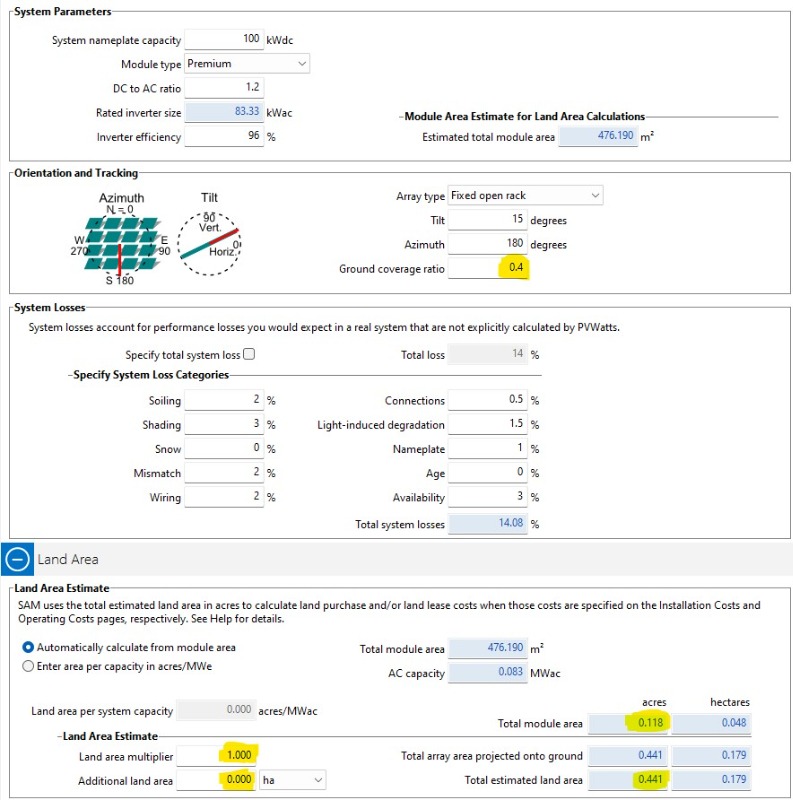
Thanks, Paul, for the quick reply. So, with this definition of ground coverage ratio that does away with the “projected onto ground”, the calculations make sense and I agree that then the GCR is independent of the tilt angle. However, referring still to Figure 2 of the previous document, the projection of Lside to the horizontal is smaller than Lside itself, so one must accept that the GCR can technically be higher than 1.0 (although that might lead to too much self-shading). The current definition in SAM 2023.12.17 help file indicates that the GCR must be between 0.01 and 0.99; and SAM itself fails when the input GCR is more than 0.99. Let’s also note that the help file indicates also that “SAM calculate a land area estimate from the total module area, ground coverage ratio (GCR) and module tilt angle.” Maybe, needs to also adjust that language in the next release.Now, about the 0.67 figure, the attached image is a capture of SAM PVWatts module. GCR is 0.4 and module area is 0.118 acres. So, one would expect the land area to be Aground = Aarray/GCR = 0.118/0.4 = 0.295 acres, with the multiplier being 1 and the additional land area set to 0. Instead, the land area is 0.441, i.e. 0.295/0.67? Thanks for clarifying this as I am not sure yet what I am missing here.
Please Log in or Create an account to join the conversation.
- Paul Gilman
Less
More
- Posts: 5706
25 Jan 2024 10:02 #12855
by Paul Gilman
Replied by Paul Gilman on topic Land Area, Tilt and Ground Coverage Ratio
Hi Demba,
There are a few issues with the land area calculations, variable labels, and documentation that we will fix for the first update to SAM 2023.12.17. Thank you for brining them to our attention.
You can track progress on this issue on the SAM GitHub repository: github.com/NREL/SAM/issues/1682
Best regards,
Paul.
Please Log in or Create an account to join the conversation.
Moderators: Paul Gilman