


- Posts: 3
SAM's weather file coordinates does not match with actual site
- Hamza Mahmood
- Topic Author
Less
More
26 Jan 2021 22:35 #9238
by Hamza Mahmood
SAM's weather file coordinates does not match with actual site was created by Hamza Mahmood
Hello Everyone,
I'm a freelancer and using SAM to design a solar battery storage system for a site located in Santos Dumont, Brazil. The site's actual longitude and latitude are -21.46, -43.55 whereas when I download the weather file for Santos Dumont in SAM, it shows -20.5 and -40.3. Both these coordinates have a very major difference in terms of the distance between them. Any information shared regarding the reliability of SAM's result in locations like Santos Dumont and Rio de Janeiro will be highly appreciated.
Warmest Regards,
Please Log in or Create an account to join the conversation.
- Paul Gilman
Less
More
- Posts: 5707
27 Jan 2021 16:00 - 19 Jan 2022 10:34 #9242
by Paul Gilman
Replied by Paul Gilman on topic SAM's weather file coordinates does not match with actual site
Dear Hamza,
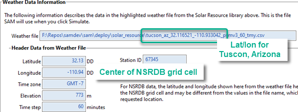
Each weather file returned by the NREL National Solar Radiation Database (NSRDB) is the solar resource for an approximately 4 square km grid cell. When you use a latitude and longitude to request a weather file from the NSRDB, the database returns the file for the grid cell that covers that location. The latitude and longitude of in the weather file is for the center of that grid cell, which may be different from the latitude and longitude you requested.
When you use SAM to download a weather file from the NSRDB, it includes the latitude and longitude used to make the request in the file name. SAM uses a geocoding service to translate the location name or address you provide into a latitude and longitude pair.
SAM displays the file name and latitude and longitude from the weather file on the Location and Resource page under "Weather Data Information." For example, this screenshot shows the result of a request I made using the location name "Tuscon, AZ:" The geocoding service returned the latitude/longitude pair 32.116521,-110.933042 that you can see in the file name. SAM then used that latitude and longitude to request data from the NSRDB, which returned a weather file for the grid cell centered 32.13,-110.94 that you can see under "Header Data from Weather File:"
Best regards,
Paul.
Attachments:
Last edit: 19 Jan 2022 10:34 by Paul Gilman.
Please Log in or Create an account to join the conversation.
Moderators: Paul Gilman